UNITED STATES: EVALUATING THE EFFECTIVENESS OF LARGE AIRTANKER DROPS
BY DAVE CALKIN, CAL BRYAN AND JIM RIDDERING
There has been a small but growing body of research within the United States on the use and effectiveness of aviation over the past 15 years; much of this focused on large airtankers.
Studies have focused on understanding where and when aviation drops occur, how fire managers prioritize the use of aviation, optimal fleet design, and how risk management concepts can inform where and when to most effectively apply aviation.
The most expansive research effort to date was the Aerial Firefighting Use and Effectiveness (AFUE) study initiated in 2012 to “systematically document the operational utilization and tactical contribution of aerial firefighting resources that have the ability to deliver water and wildland fire chemicals in support of incident objectives.”
As part of the AFUE study, the research team coordinated with incident commanders to collect data on aviation use on 272 wildfires from 2015 to 2018, including more than 5,000 airtanker retardant drops. The research team recorded the primary suppression objective for each retardant drop based on radio communication, operational briefings, and/or post-hoc conversations with incident management. Drops were then categorized into a variety of different outcomes, including no fire interaction, burned through, halted fire spread, and others. The research team then created performance metrics to measure the likelihood of aviation drops interacting with wildfire and their probability of success.
The AFUE study included observations for a variety of aviation platforms dropping water and retardant.
Halting fire spread and delaying fire spread were the two most common objectives for retardant drops, each representing more than 40 per cent of drop objectives with point protection coming in a distant third at 10 per cent. About one-quarter of all large airtanker (LAT) drops did not interact with the final fire perimeter, demonstrating the use of airtankers for indirect suppression tactics and contingency line development. Not surprisingly, for those drops that interacted with wildfire, the probability of successful drops intended to halt fire spread was lower (55 per cent) than the objective of slowing fire spread (75 per cent) and point protection (87 per cent). Although the AFUE study provided a level of detail regarding drop objectives and relative measures of success, there was an important question unanswered: do these mission objectives truly alter wildfire outcomes during extended attack?
Researchers at Colorado State University are engaged in a study to provide formal calculations on the effectiveness of large airtanker retardant drops at altering wildfire growth. The researchers use data provided by units mounted inside LATs that record the exact locations and times of retardant drops, along with information on the daily growth of wildfires from 2017 to 2019, to evaluate fire characteristics before and after the wildfire passes over the retardant line. The researchers evaluate the change in wildfire characteristics as the fire moves through a swath of land that is split by the retardant line. However, a critical piece of information to understand the effectiveness of LAT suppression at the drop level is a comparison with areas unaffected by retardant.
To ensure accurate comparisons, the researchers measure wildfire outcomes in adjacent areas with similar vegetation and topography. The key difference? These areas lack retardant lines, serving as a control, thus creating what is known as a natural experiment. The difference in the change in wildfire outcomes as the fire moves through these two swaths of land provides statistics for the effectiveness of LAT retardant drops.
The researchers evaluated the effectiveness of LATs at halting wildfire progression, reducing the intensity, and delaying the spread of wildfire; they found that LATs are effective at altering wildfire outcomes in all three ways.
Wildfire is 8.4 per cent less likely to spread into land that is protected with an LAT drop compared to land that is not buffered by retardant.
Similarly, the intensity of fire (measured by the gridded Monitoring Trends in Burn Severity layer) is 7.5 per cent lower for land protected by a retardant line.
Land protected by retardant takes four to five hours longer to burn than unprotected areas, giving crews crucial time to respond.
These findings reveal the tangible impact of LAT drops on wildfire behavior, offering key insights for suppression strategies.
These statistics aggregate the effectiveness of retardant drops across a variety of landscape and weather conditions. However, the Colorado State researchers have found that LATs are more effective across all three dimensions when dropping on land covered with shrub vegetation, compared to areas dominated by grass or trees. They have also found that air tankers can delay the spread of wildfire by more than 30 hours when used in conjunction with other types of suppression, and that tankers classified as very large airtankers, or VLATs, based on larger tanks for holding retardant, can reduce the likelihood of fire spreading by roughly 12 per cent relative to land not protected by any retardant drops. This research also provides assessment of the influence of topography and general weather conditions on drop line effectiveness.
Understanding the effectiveness of large airtanker drops is a crucial step in refining wildfire suppression strategies, but translating research results into actionable feedback for incident management teams remains a challenge.
Developing processes to review past actions and provide near real-time information to the field is essential for improving future wildfire responses and maximizing the effectiveness of airtanker use.
As such, researchers and fire managers have been using additional telemetry units (ATUs) to track various metrics associated with air tanker drops. ATUs are mounted on all federally contracted airtankers (and some single engine airtankers – SEATs). ATUs are GPS-enabled devices that track parameters such as aircraft location, time, heading, altitude, and most importantly, tanker door open and close events.
ATU data have been used since 2017 to calculate air tanker drop locations and associate various analytics with those drops. These original aviation use summaries (AUS) were manually produced and provided to fire managers through the US Forest Service’s Risk Management Assistance (RMA) dashboard to help inform how fire chemical and water were being applied to the landscape.
Additionally, the AUS process can be used as a powerful after-action review of the effectiveness of aviation drops in supporting suppression actions. Original metrics associated with the AUS reports focused on analyzing time of day, fuel types, and slope classes where the drops were occurring. Subsequent AUS development used the rise of integrated metrics such as suppression difficulty index (SDI) and potential control locations (PCL) within the RMA dashboard to provide additional context for managers to evaluate the use of air tanker drops on incident strategy and tactics.
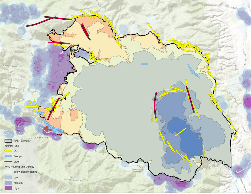
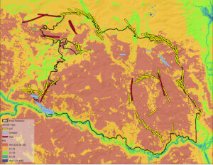
More recently, US Forest Service personnel have worked to automate the processing of ATU data to expedite the production and distribution of airtanker drop information and associated analytics. Daily processing starts by creating lines from ATU GPS point data for door open and door close events. These derived drop lines are then extended to account for forward momentum of the fire chemical or water. Next, drop lines are buffered and values for SDI, PCL, slope, elevation (of the line), and majority fuel model are extracted for the buffer, and appended back to each drop line feature class (Figure 1). A significant amount of processing time is devoted to quality assurance to remove redundant or bad data points and ensure the creation of logical drop lines. Problematic lines are flagged as possible false positives but retained in the database. Other attributes added include split drop information (where a tanker will split the load and do multiple drops in one flight), the calculation of various time parameters, and incident name association. The final step updates an ArcGIS Online (AGOL) Feature Service. The feature service feeds an AGOL dashboard that is available to credentialed managers and users. Work continues to improve estimation of gallons dropped and tracking costs associated with flights.
Through the automated processing and near-real time distribution, users such as incident management team members, aviation officers, and coordination center managers are better able to monitor drop locations (including areas of misapplication), assess the use of air tanker resources on their incident, and build knowledge using derived analytics to help them evaluate the effectiveness of air tanker resources.
This work highlights the importance of integrating research findings with managerial experience to determine effective resource use. Dan Dallas, an incident commander with the US Forest Service in Colorado and early adopter of the AUS system explained the value.
“The AUS provides us the ability to examine recent drops in near real time on fires we manage giving us the information necessary to identify where and when aviation could best support suppression actions. Using the AUS to examine our management of past events allowed us the opportunity to think more clearly about how aviation can best support our incident strategy. This has allowed us to clearly articulate our strategy in aviation use to the hosting unit and our field-going personnel. We firmly believe the use of AUS has significantly improved the effectiveness and efficiency of our suppression actions and overall fire strategy.”
Aerial drops are probably the most iconic and visible activities in wildfire suppression and often a critical component to initial attack and large fire suppression strategies. The effectiveness and efficiency of wildfire suppression actions writ large is poorly understood, and we largely rely on the experiences of incident management team members and field-going firefighters to determine what resources are needed and where they should engage.
Aviation is but one component of wildfire suppression and the coordination of the broad array of ground and aerial resources is a highly complex process.
The AFUE study provides an indication of the type of objectives and conditions of effectiveness but did not uncover how objectives contribute to overall fire suppression outcomes.
Given the costs of wildfire suppression, exposure of ground and aviation personnel, and the impacts to natural and developed resources, improving the effectiveness and efficiency of wildfire management is essential and understanding aviation’s role will be critical to that effort. Progress will be contingent on the ability for researchers and managers to work together to foster more safe, effective, and efficient solutions.
 Dave Calkin is a supervisory research forester with the US Forest Service, Rocky Mountain Research Station in Missoula, Montanna. Calkin’s work is designed to improve risk-informed decision making through innovative science development, application, and delivery incorporating economics with risk and decision sciences. Calkin’s research interests include risk assessment, collaborative wildfire mitigation and response planning, suppression effectiveness, and risk informed decision making. Calkin developed and leads the Wildfire Risk Management Science (WRMS) team within the US Forest Service Rocky Mountain Research Station.
 Cal Bryan is a post-doctoral researcher in the Agricultural & Natural Resource Economics department at Colorado State University, interested in researching methods to optimize operational resources for fighting large-scale wildfires. Bryan holds a bachelor’s degree in bioenvironmental sciences from Texas A&M University, a master’s degree in economics from San Diego State University, and a PhD from Colorado State in agricultural and natural resource economics. Bryan’s PhD dissertation, titled Evaluating the Efficiency, Equity, and Effectiveness of Wildfire Suppression Strategy Using the Microeconomic Toolkit, focuses on determining patterns in large airtanker use across wildfires in the United States and their effectiveness at altering wildfire outcomes. Before starting graduate school, Bryan spent several years working seasonally for the U.S. Forest Service in various roles, including trail crew supervisor, interpretive ranger, and type-II wildland firefighter.
 Jim Riddering is an aviation analyst with the Strategic Analytics Branch of the U.S. Forest Service Office of Fire and Aviation Management. Riddering’s responsibilities include managing the Additional Telemetry Unit (ATU) program, developing data processing streams, and providing analysis of aircraft use. Riddering holds a PhD in forestry from the University of Montana and has more than 20 years of wildland fire experience, including time on hotshot and engine crews. Riddering is a qualified Aerial Observer (AOBS), holds a private pilot’s license (SEL), and is working on completing his Long-term Analyst (LTAN)
