Putting people first: Using social science to reduce risk
BY PATRICIA CHAMP, CHRISTOPHER BARTH, HANNAH BRENKERT-SMITH, LILIA FALK, JAMIE GOMEZ, JAMES MELDRUM
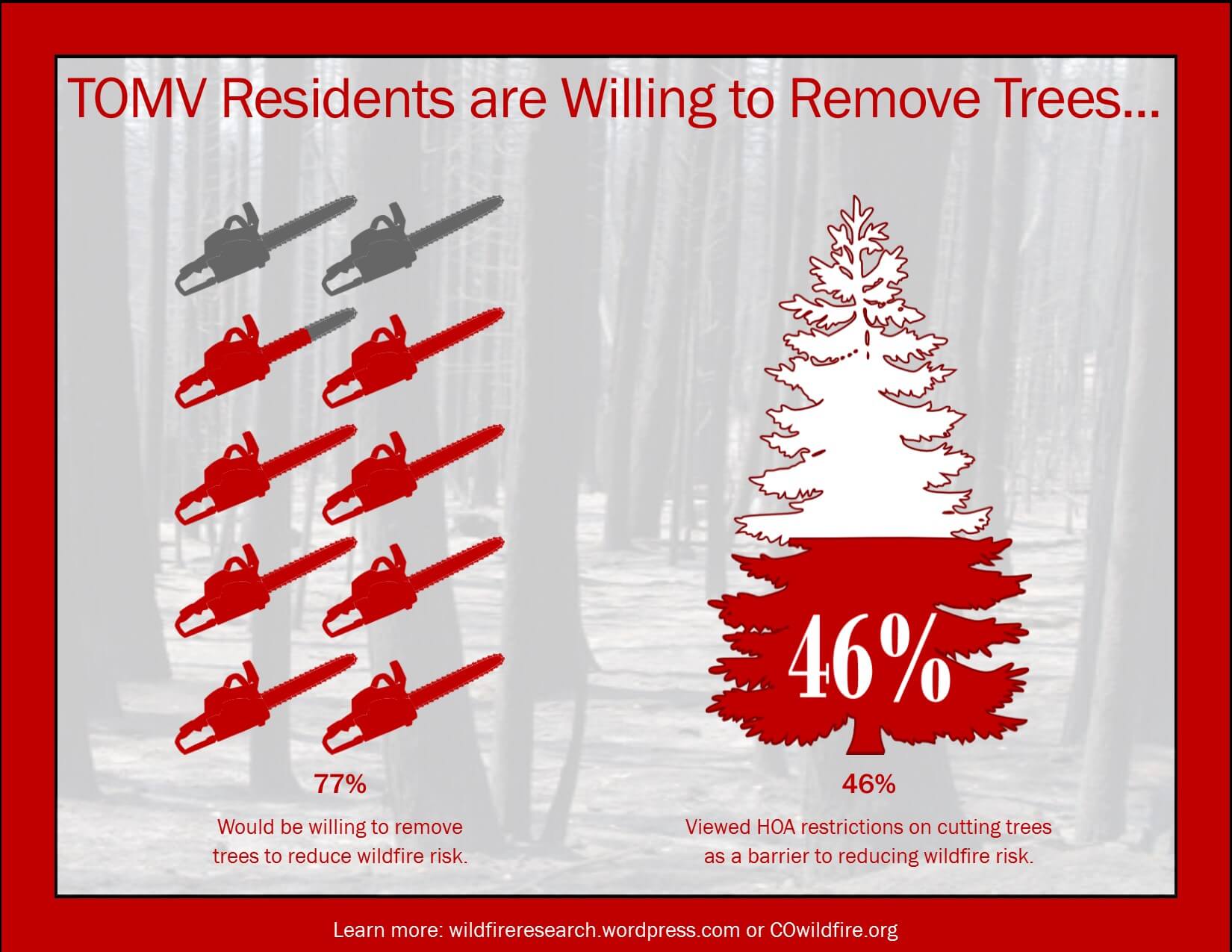
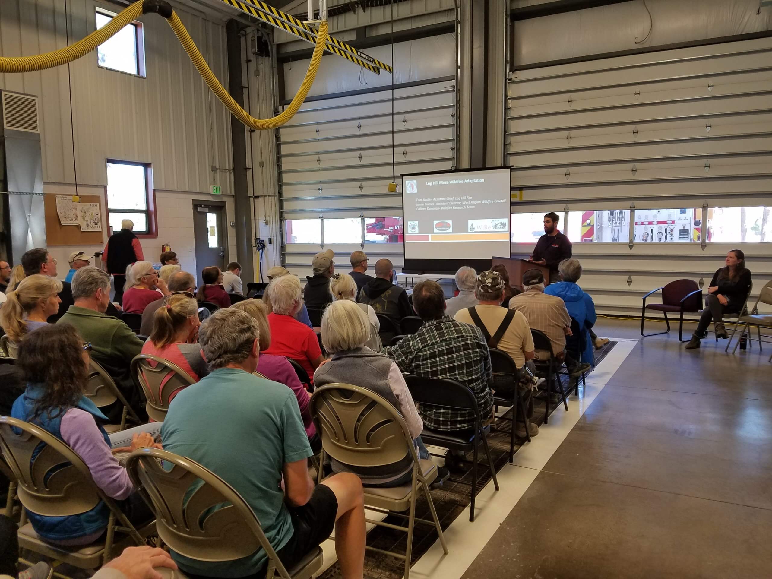 Research team member Jamie Gomez presents survey results to community members in Town of Mountain Village, Colorado. Researchers determned that homeowners were willing to remove trees to reduce wildfire risk but almost many viewed homeowner association restrictions on tree cutting as a barrier.
The director of West Region Wildfire Council stood before council for the Town of Mountain Village in southwest Colorado with community social data in hand. Over the course of the next hour, Lilia Falk presented key points that refuted the dominant assumption that local residents were not concerned about wildfire, nor were they willing to cut down trees on their properties to mitigate wildfire risk.
Falk’s data from a 2014 community survey showed that most Town of Mountain Village residents were indeed willing to remove trees to reduce wildfire risk. However, almost half of the residents viewed local homeowner association restrictions on tree cutting as a barrier. The availability and presentation of locally relevant social science did two things: first, it changed the conversation in the community; second, it identified a path forward for the town council.
The lesson learned? Locally tailored social science can foster needed transformations in local and regional conversations about new, sustainable pathways toward reducing wildfire risk to communities.
A future with more large wildland fires in western North America and the central role of the wildland-urban interface (WUI) is well established. Though fire is a natural and important part of many ecosystems, a wildland fire becomes disastrous if it results in substantial harm to social and natural systems. WUI residents, who occupy the areas where wildlands meet and mix with human development, are both contributors to and recipients of the disastrous effects of wildland fires. WUI residents contribute through fire starts, flammable homes, unmitigated properties, opposition to mitigation on nearby public lands, and land-use planning efforts; they also lose their homes, inhale smoke, and suffer economic losses.
What is the best way to avoid wildfire-related community destruction? Fire science and experience suggest that the success of suppression efforts in the context of high winds, low humidity, and dry vegetation characteristic of recent wildfires in the western United States is limited. Clear guidelines on how to create ignition-resistant homes and how to reduce fire transmission immediately around homes have been established and tested. If home ignitions are central to community destruction during extreme wildfires and the solution is known, why do wildfires continue to devastate communities?
There is a significant gap between established guidelines and persuading WUI residents across diverse communities to implement changes on their parcels. Our view is that the social aspects of wildfire risk reduction have received too little emphasis. It is not sufficient for science to provide solutions without considering the path to science implementation. This gap can be addressed with systematic, rigorous co-productive social science that can guide and measure action. Successful, sustainable wildland fire solutions are only possible if the WUI residents are engaged. While wildfire research and policy recognize that people and the communities that they live in are diverse, there has not been enough attention to how social data can guide action.
Efforts to build community wildfire resilience often focus on the biophysical aspects of fire science, which provides guidelines on how to reduce the likelihood of homes igniting during a wildland fire, through such actions as changing structure characteristics or managing vegetation near the home.
However, the value of biophysical fire science is determined by the extent to which residents in fire-prone communities implement the guidelines. To date, implementation has fallen short. In addition to the social aspects of wildfire risk reduction not being sufficiently recognized, little of the social science research to date has prioritized the provision of actionable results to guide local risk reduction efforts.
Understandings of human behavior within a social context can provide evidence needed to move biophysical fire science guidelines from theory to practice. General understandings about human decision making under risk are a good start but insufficient for incentivizing action across diverse populations. For example, cost-sharing programs that defray the cost of vegetation removal on private land directly allocate resources to residents to incentivize mitigation.
However, there is little evidence about whether cost-sharing programs are the right tool for WUI residents or how large the cost share needs to be to incentivize mitigation.
When we examined the issue in a the community of Log Hill Mesa, we found that both financial and informational factors influenced participation in a local cost-sharing program. Compared to those living on lower-risk parcels, the residents living on the properties with the highest wildfire risk ratings were less likely to participate in the cost-sharing program. In other words, a cost-sharing program was not found to be a good tool for targeting high-risk parcels in that study community. Further, the residents who were willing to participate in the program expressed a willingness to bear a larger share of the cost than the program required at that time. Based on these results, the local practitioners, who were involved throughout the research process, redefined the terms of the local cost-sharing program.
Government policy, local ordinances, land-use planning, and insurance companies are all important levers that can encourage fire risk mitigation on private land. Nevertheless, community-based wildfire programs are often the key resource in moving WUI residents to mitigate wildfire risk.
Despite operating under widely varying funding and staffing conditions, wildfire practitioners usually have competency regarding the latest biophysical fire science and experience-based insights into local residents and the social dynamics within the community. However, limited resources often impede practitioner engagement with the entire community. Instead, a small but vocal subset of residents may drown out the voices of the broader community. Lacking local data, practitioners often depend on knowledge extrapolated from other contexts. As a result, programs are often unduly influenced by anecdotes rather than evidence.
We argue that locally relevant, standardized social science that is co-produced with practitioners can be a foundational element to successful community wildfire programs. Without the broad-scale implementation of vegetation management and structural hardening on private land, wildfire solutions will remain elusive.
Attributes of an effective evidence-based model
Social science takes many forms, from qualitative inquiries to quantitative survey-based methods to analyses based on big data. We describe an evidence-based quantitative social science model that builds from wildfire social science to provide practitioners with locally relevant information that empowers them to implement effective programs, facilitate learning, and monitor change over time.
First, the model calls for social science that is conducted at the level at which the program is being implemented; this is critical. Social data must include an adequate number of observations within a community to be representative, informative, or actionable.
Social data collected at a national, state, or even county scale, for example, may not adequately downscale. Georeferenced and representative community social data can be merged with other data, such as parcel-level rapid wildfire risk assessments and/or property assessor data. Georeferenced data can also be embedded within a broader context of landscape conditions.
Second, the social data should be standardized across communities to allow for comparisons of similar communities in different locations, dissimilar communities near each other, and individual communities across time. 
Third, co-production of knowledge by researchers and practitioners will ensure the relevance and usefulness of results. Co-production requires trust between researchers and practitioners who may not initially frame the problem or potential solutions in a similar light.
Trust can be fostered if relationships are iterative and long-term. A truly co-productive process is best facilitated by honest conversations about tensions that arise when researchers and practitioners view problems differently. While co-production usually requires substantial effort, the rewards include credible, relevant results and evidence-based practice.
An example
We are wildfire practitioners and researchers (the Wildfire Research or WiRē team) who have been working together more than 15 years to support evidence-based wildfire risk mitigation programs. How the team engages is almost as important as the outcomes of the engagement. We work together to define the issues, develop research designs that allow for learning, interpret results, and integrate research into programs.
Parcel-level rapid wildfire risk assessments of all homes within a community or a fire protection district are a common tool used by community wildfire programs. While the assessments vary, they usually include coarse measures of the ignitability of structures and vegetation on the parcel, attributes related to the location of the parcel – for example, slope, proximity to dangerous topography – and the ability of the fire department to access the parcel.
The WiRē approach pairs social surveys to the georeferenced parcel-level rapid wildfire risk assessments. Pairing biophysical and social data goes beyond providing a snapshot of risk to providing insights into why a parcel may or may not be mitigated, differences in the perspectives of the wildfire practitioner and the parcel resident, and which programmatic tools are best suited to diverse community residents. In other words, the results provide evidence about the nature of the social issues related to wildfire in a community.
Residents take action to mitigate wildfire risk based on their perceptions of that risk and wildfire practitioners administer community wildfire programs based on their notions of the parcels at greatest risk within a community. Pairing social survey data with parcel-level rapid wildfire risk assessments allows for measurement of gaps between the risk perceptions of residents and wildfire practitioners.
In a 2015 study, the WiRē team found evidence of gaps between many attributes of a parcel-level risk assessments conducted by a wildfire practitioner and parcel-level risk assessments self-reported by residents. The wildfire practitioner’s assessment and residents’ self-reports of overall parcel risk ratings diverged on average, as did judgments about many specific property attributes and the relative contribution of these attributes to a property’s overall level of risk.
When there was agreement, for example the presence of an ignitable roof, residents underweighted the importance of an ignitable roof on a parcel’s overall risk compared to the wildfire practitioner. Subsequent unpublished evaluation has demonstrated the consistency of these general results across a wide variety of communities and contexts, but with important local nuances. Understanding the nature of these kinds of risk-perception gaps can serve as the basis for targeted communication by wildfire practitioners.
Wildfire community programs often struggle with metrics to show progress toward wildfire adaptation. The number of acres or hectares of land where vegetation has been removed to mitigate fire risk is a commonly used metric that may not reflect actual risk reduction, much less social progress on mitigating wildfire risk.
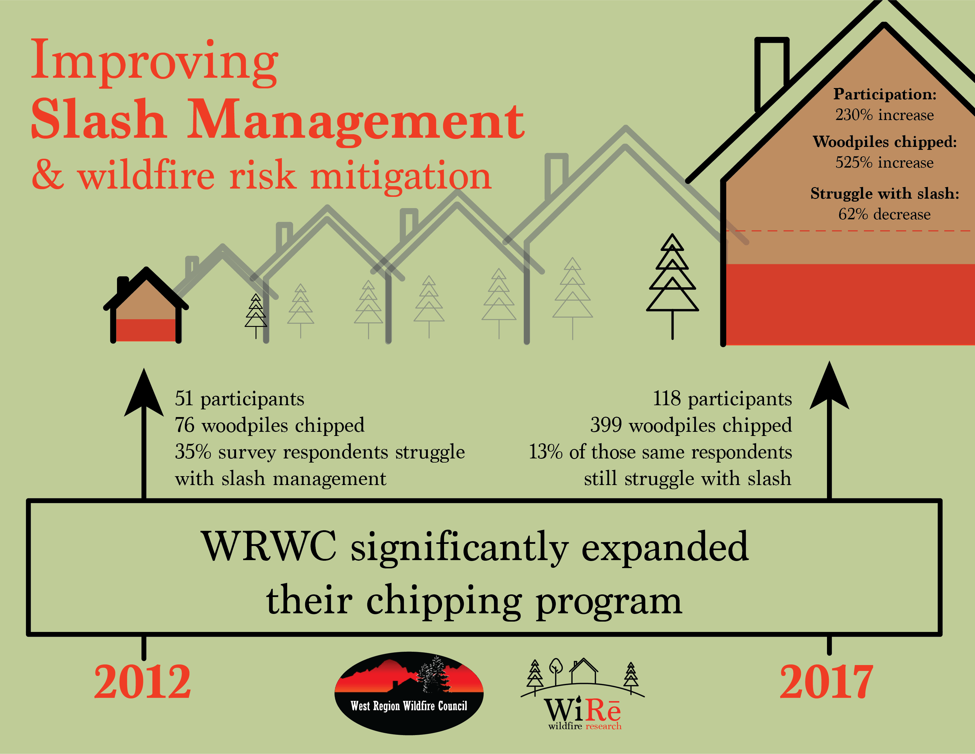
The WiRē approach was implemented in 2012 and repeated in 2017 in the Town of Mountain Village. In 2012, 35 per cent of the survey respondents said they struggled to get rid of the slash that accumulated from wildfire risk mitigation work.
The local wildfire council acted on this information and expanded a program that chipped up slash from parcels. Five years later, 13 per cent of survey respondents cited slash removal as a barrier to mitigation. The wildfire council was able to report a 230 per cent increase in participation in the chipping program, a 525 per cent increase in woodpiles chipped, and a 62 per cent decrease in residents who struggled with slash removal. Comparing standardized data over time provides evidence of program success.
There is a tendency to want to scale up successful local efforts. However, our view is that in the context of wildfire mitigation across diverse WUI communities, there is more value in scaling out to learn which findings are location-specific and which might transcend location.
The WiRē approach has been refined through repeated applications across space and time. While each effort is shaped by the needs of the local program, core data are standardized across applications. This approach is relatively unique in the social sciences. Further, the team has developed a comprehensive dataset that is updated each time the WiRē approach is implemented in a new location. Analyses of the comprehensive data provide insights into which results generalize across communities and which are location specific. For example, aggregating social data from 68 communities across six counties in southwestern Colorado, we found that general attitudes about wildfire and what can or should be done about it were similar across different communities and counties. However, the social characteristics of a community that can guide programs such as where residents get information about wildfire, expectations about what will happen in the event of a wildfire, and measures of mitigation and preparedness, were found to vary substantially across communities.
In sum, our position is that that social data collected at the scale of local programs, standardized to allow for replication across space and time, using a co-productive process that intertwines research and practice, help assure that the science is useful and actionable.
ABOUT THE AUTHORS
 Patricia Champ is a research economist with the USDA Forest Service, Rocky Mountain Research Station. Contat her at [email protected]
Christopher Barth is a fire mitigation and education specialist with the Bureau of Land Management – Montana/Dakotas
Hannah Brenkert-Smith is with the research faculty, University of Colorado, Institute of Behavioral Science
Lilia Falk is director of finance, agreements and human resources with the West Region Wildfire Council
Jamie Gomez is director of the West Region Wildfire Council
James Meldrum is a research economist with the Fort Collins Science Center, U.S. Geological Survey
