(Potential Operational Delineation) boundary is in the foreground along a paved Forest Service road. Photo: Kari Greer.
Evolving approaches to wildland fire management – integrating pre-planned
control lines and operational decisions with quantitative risk assessment –
support a safer and more strategic response to fire-prone landscapes.
SUMMARY: For more than a century in the US we have been suppressing fires, with unexpected and undesirable outcomes particularly in fire adapted and dependent ecosystems. Fires are increasing in size and duration, resulting in substantial loss of life and property. It is time for a different approach in wildland fire management. National policy mandates that federal agencies focus on the protection of life, property, and resources by a risk-based and shared-stewardship approach while leveraging emerging technologies.
An emerging concept is strategic wildland fire management planning (SWFMP), focusing on preseason, fire season, and postseason planning and implementation to aid fire managers, decision makers, and operations to be more successful and safer. Techniques scale together and include the use of Potential Control Locations (PCLs), Potential Operational Delineations (PODs), and wildfire risk assessments. Both the challenges and benefits of these approaches are demonstrated and an example of their use is shared from the Pacific Northwest.
Download a PDF: Wildfire 2020-01 Strategic fire management Stratton
+
by Richard D. Stratton
What we are doing is not working. For more than a century we have been suppressing fires in most ecosystems, particularly in the western US. We are really good at it—95+% (Booz Allen Hamilton, 2015; USDA, 2015). As a result, instead of a healthy patchwork of different aged stands of vegetation, we have large expanses of vertical and horizontal continuity of fuels conducive to large fire growth (Hessburg, 2017). Inadvertently, we have now predisposed many of our fire-prone landscapes to large destructive wildfires. This physical situation has been compounded by insect and disease, invasive species, climate change, and land management. Now factor in our love of living in the forest. It is estimated that the wildland-urban interface is the fastest growing land-use type in the conterminous United States (Radeloff et al., 2018). When this increasingly complex fire environment receives an ignition, particularly during extreme weather and fuel conditions, the ecological, social, economic, and human impacts are often dreadful.
It is estimated that the western Regions of the US Forest Service—Regions 1 through 6—need to burn, on average, 5 to 7 times more acreage—based on Monitoring Trends in Burn Severity estimates (Finco et al., 2012) from 1984-2010 vs. LANDFIRE (Rollins and Frame, 2006) mean fire return interval (McHugh and Finney, 2014). Prescribed fire is a means for increasing area burned, but it isn’t at a scale commensurate with need. In fact, if we don’t do it Mother Nature will. For example, in 2018, Regions 1 – 6 of the Forest Service treated approximately 440,500 acres with prescribed fire vs. wildfire acres of 1.8 million. If our primary goal is to mitigate large fire growth and the inevitable losses to highly valued resources and assets (HVRAs), we are not going to “treat” our way out of the problem in most fire-prone landscapes—the problem is too big, our treatments are too small, and they are taking too long to implement.
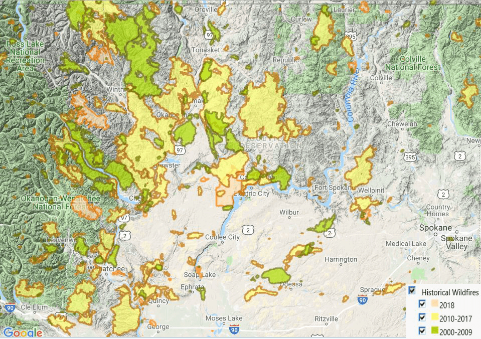
Figure 1 (right) displays the last 19 years of large fire history in north-central Washington as shown in the Wildland Fire Decision Support System (WFDSS) (Noonan-Wright et al., 2011). The sizes and frequencies of these fires are sobering, loss of life, injury, and property heartbreaking, and due to the uncharacteristic fuel conditions, several of the ecological outcomes were undesirable. Ironically, when we desperately need our suppression resources to be most effective—that is when they are often least effective (Finney et al., 2009). The reality is, the only way to check the spread of a large wildfire is for it to encounter another recent large fire(s), very sizable fuel treatment(s)—or a very large network of smaller treatments—or to receive a significant change in the weather (e.g., fire-stopping or season-ending event(s)) (Finney et al., 2005; Stratton, 2006). When this occurs, suppression resources can get the upper hand (Finney et al., 2009).
Table 1 (below) looks at large fires in the Pacific Northwest and their historical ranking in the last 50+ years on federal and state lands. All but 4 of the units have experienced one of their largest fires in the past 8 years (2011-2018)—but what may be more sobering is many have experienced their top 2 or 3. The take home is obvious. Fire is inevitable in many ecosystems in the West and we have reached a tipping point where several forests and range lands are transitioning to a larger, uncharacteristic fire frequented landscape—it is time for a different approach to fire management.
A different approach…
Let’s face it, there are just some places we have to suppress fires no matter the ecological or financial cost due to personal property and life safety, critical infrastructure, or public, political, or cooperator pressure. There are many examples of this recently, but where we have more decision space—which is a large portion of the Western landscape—we need a different approach to managing fire.
O’Connor and Calkin (2019) outlined the use of Potential Operational Delineations (PODs) (Thompson et al., 2016) on the Pinal Fire, in a recent paper “Engaging the fire before it starts.” The authors outline how preplanning efforts on the Tonto National Forest, to develop potential control locations (PCLs) (O’Connor et al., 2017) and PODs, aided in the strategy to contain the fire near Globe, AZ.
The purpose of this paper is to (1) explain why a new approach is needed—as provided above, (2) summarize recent national fire direction and policy, (3) list the benefits and challenges of PODs on a fire-prone landscape, (4) demonstrate how this approach can integrate into a broader strategic wildland fire management planning (SWFMP) framework, (5) provide guidance to fire mangers on how to apply SWFMP, and (6) provide an example of how these concepts were applied while managing a wildfire.
…supported by recent policy & direction
Recently the President of the United States issued an executive order (EO 13855) to the Secretaries of Agriculture and Interior. Section 2 (Goals) stated: “To protect communities and watersheds, to better prevent catastrophic wildfires, and to improve the health of America’s forests, rangelands, and other federal lands, the Secretaries shall each develop goals and implementation plans for wildfire prevention activities and programs in their respective departments.” (Federal Register, 2019)
In response to the order, the Chief of the Forest Service stated that “We will do the right work in the right place at the right scale using advanced science and mapping tools” (USDA, 2018, p. 2). The response from the Secretary of the Interior was a 6-page order (3372) to the Bureaus, which included a directive to: “Maximize the wildfire management benefits of physical features within landscapes.” It elaborated on the use of physical features, in conjunction with vegetation management techniques, to help control catastrophic wildfires, such as rivers, streams, geological formations, roadways, etc. (USDI, 2019).
This comes on the heels of changes to Forest Service (Chapter 5140) and Department of the Interior (Manual 620, Chapter 6) direction in 2017 to utilize risk assessment information for the identification and prioritization of fuel treatments. All of this policy and direction is consistent with the National Cohesive Wildland Fire Management Strategy (USDA, 2011) and Shared Stewardship. “A steady increase in collaboration capacity and recent breakthroughs in Forest Service science, mapping, and technology are providing new tools for planning investments to reduce fire risk and improve forest conditions. We will implement these new authorities and advances in technology by: Working with States to set priorities and co-manage risk across broad landscapes. The most effective approach to wildland fire management is shared stewardship of the wildland fire environment, shared ownership of the challenges it presents, and a shared commitment to meeting those challenges….”(USDA, 2018, p. 2).
Spatial planning with PCLs and PODs
PCLs are areas where large fires historically tend to stop or lull, due to topographic features such as lakes, ridges, and rivers; roads and trails; fuel transitions; and non-burnable vegetation. They can be solely expert-informed or a machine learning algorithm can be run on a landscape to develop a map of historical containment probability, scaled 0 to 100% (O’Connor et al., 2017). PCLs can be linked together to form PODs—polygons that are typically thousands of acres. Think of PODs as hydrologic units codes (HUCs), but instead of the land area where water drains to a specific location (watershed), PODs are based on fire spread. Fifth or sixth level watersheds or a fireshed (Bahro et al., 2007; Scott and Thompson, 2015), usually consist of multiple PODs.
There are many benefits for developing PODs, particularly on fire-prone landscapes; there are also a few challenges and cautions.
Benefits
- Use of fire in PODs are a compromise between what we know many of these fire-adapted and dependent ecosystems need, vs. agency tradition and personal preference, protection of HVRAs, and political pressure. Likewise, it is a middle-ground with other federal agencies, State, and local partners.
- In many ecosystems, we need more fire on the landscape—PODs can help us get there on a broader scale, particularly when implementing a confine, monitor, and point and/or zone protection strategy. Recently burned PODs will help us control future large fires and is an intervention to help us reach the goal of a self-regulating fire system in fire prone environments.
- PODs promote shared stewardship and can help us achieve the goals of the Cohesive Strategy (USDA, 2011). By working with partners, we can plan an expectation together before the fire occurs and partners will be more apt to support an action on the ground, if they were first involved with the strategy.
- PCLs and PODs can be identified before fire season by local expertise—when there is no “emergency”—and incorporated as part of the planning process.
- In addition to developing and implementing a strategic response for a wildfire, PODs can be utilized in the off season for prescribed fire planning and implementation.
- There are usually less constraints on personnel, funding, and smoke managing a wildfire utilizing PODs vs. the implementation and maintenance of prescribed fire or fuel treatments.
- Beneficial fire effects can often be realized while utilizing PODs, particularly in times of low, moderate, and high fire danger. Even under extreme conditions, using PODs when executing burnout operations can produce a mosaic of mixed-severity.
- Sometimes on wildfires we focus too much on trying to control a fire at a difficult location due to a jurisdictional or administrative boundary. PCLs and PODs can help us identify control opportunities at locations, regardless of ownership, where firefighters can more safely and successfully engage the fire—particularly if additional mitigation measures are taken.
- PODs are delineated based on a known location on the ground that can be a tangible reference to an action, minimizing confusion where a specific action or strategy is to be employed on a wildfire.
- POD data can be quickly shared with incoming teams via Google Earth, GIS, and GPS, referenced in the leader’s intent letter, and included in the WFDSS decision.
Challenges and Cautions
- Do you have the expertise to identify and delineate the PCLs and/or verify those provided by the machine learning model, and delineate the PODs?
- It is relatively easy to create PODs, but will your local unit use them? Are local fire managers, line officers, partners, and incident management teams (IMTs) informed, in agreement, have access to the data, and expectations understood?
- Landscapes with multiple ownerships can make the POD development process more challenging, but potentially very rewarding and in alignment with national direction.
- PODs need to be part of the operations and long-term planning of a wildfire. It is critical we do not lock into a specific POD, when the next ridge or POD has a higher degree of success and/or is safer to engage the fire.
- When managing a fire, the POD approach vs. direct attack may in the short run result in a higher expense, more smoke production, and increase the fire duration.
- A long-term strategy utilizing PODs may be more difficult for the public to comprehend and support, particularly those communities who have been affected by evacuation, smoke, and reduced access in the recent past.
- If PCLs and/or PODs are prepped as containment lines, local biologists and/or resource specialists may need to be consulted.
Strategic Wildland Fire Management Planning
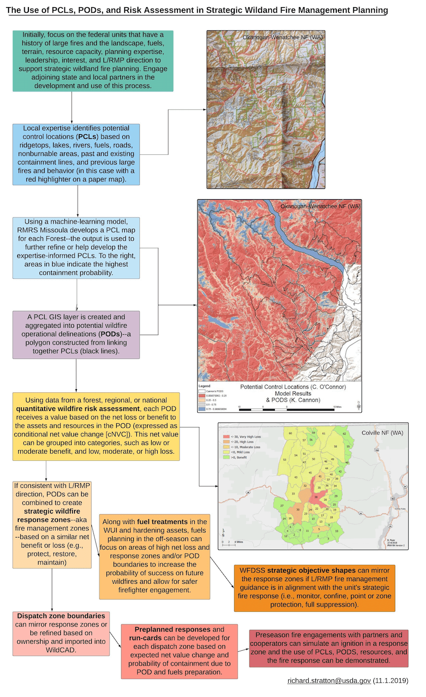
We need to do much more BEFORE the “big one” occurs—they are inevitable in many fire adapted and dependent ecosystems. We must think, talk, plan, and act more strategically on our landscapes. We have a very hard time doing this individually and as federal or state agencies. We must not wait until there is smoke in the air. This is where SWFMP plays an important role. Figure 2 is a flow chart outlining the process of using PCLs, PODs, and a quantitative wildfire risk assessment (QWRA) (Scott et al, 2013; Gilbertson-Day et al, 2018) in a SWFMP framework.
The process consists of:
- Use local expertise and/or machine learning to identify PCLs.
- Develop PODs by linking together the PCLs into polygons.
- Where available, use a local, state, or regional QWRA to assign each POD a value based on net loss or benefit to HVRAs within the POD boundary. This information is usually expressed as a conditional net value change (cNVC). This value can be grouped into categories, such as low, moderate, or high benefit or loss. For more information on the QWRA process and its application, view the following webinar: http://www.nwfirescience.org/content/overview-applications-pnw-quantitative-wildfire-risk-assessment (Stratton, 2019).
- If consistent with the Land or Resource Management Plan direction (L/RMP), strategic wildfire response zones can be developed based on similar areas of net benefit or loss. A unit can assign an ecologically-based strategic response (protect, restore, maintain) or a more operational response, like that contained in the Incident Command System 209—(full suppression, confine, point or zone protection, monitor).
- Along with fuel treatments in the WUI and hardening assets, fuels planning in the off-season can focus on areas of high net loss by POD to increase the probability of success on future wildfires and allow for safer firefighter engagement.
- Preseason planning efforts can be incorporated into fire management planning documents, electronic systems like ArcGIS Online, and spatial fire planning in WFDSS.
- Dispatch zones can mirror the strategic wildfire response zones and the preplanned response can be commensurate with loss or benefits to HVRAs.
- Preseason fire engagements with partners and cooperators can simulate an ignition in a response zone and the use of PCLs, PODs, resources, and the preplanned fire response can be demonstrated.
Implementation
Many are familiar with the Swiss cheese model of accident causation (Reason, 1990 and 2000)—a model used in risk analysis and management (Figure 3). The model illustrates that although there are often several layers of defense between hazards and losses, there can be inherit flaws in the defensive layers. If these flaws are aligned, a negative outcome is realized.
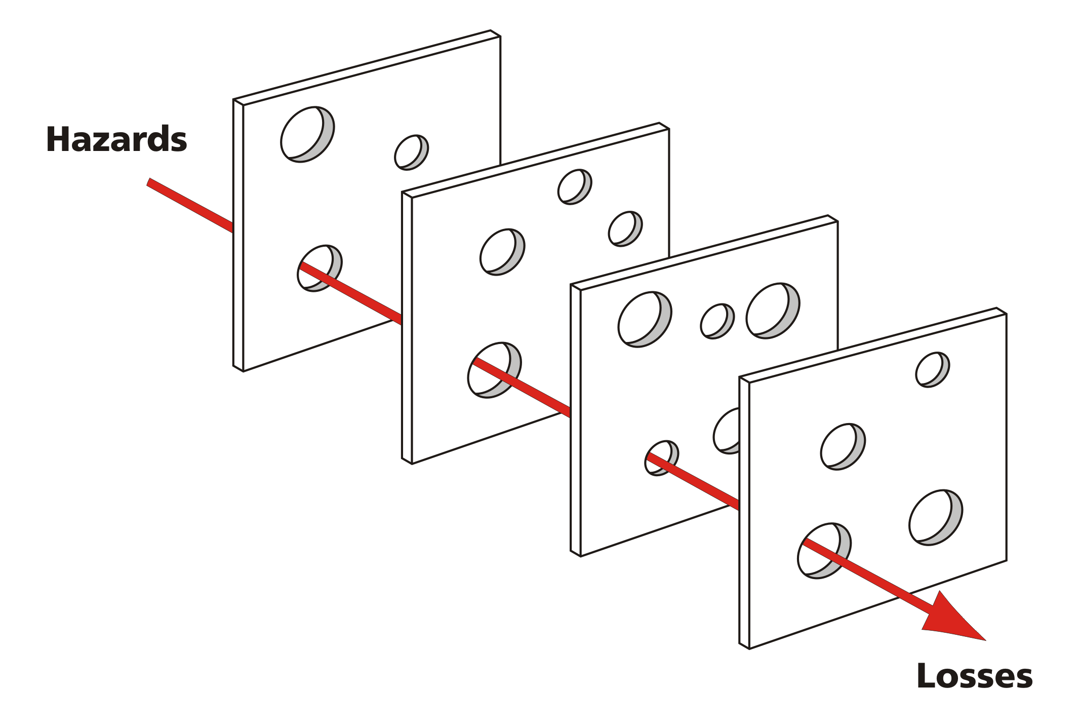
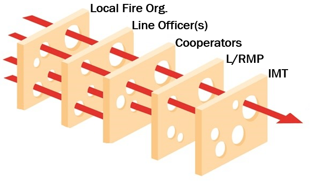
Using this conceptual model in the context of SWFMP, we can see how an improved outcome can be achieved. This is possible when there is an open dialogue and understanding with local fire management, line officers, and cooperators, and that their proposed actions are in alignment with the L/RMP. Furthermore, on wildfires it is essential the incident management team is aligned with this collaborate strategic vision. If even one of these entities is not in alignment, the strategy can fail or be in conflict with the L/RMP (Figure 4).
Example of the use of PODs (Cougar Creek Fire 2018)
The Cougar Creek fire started from a lightning strike July 28 on the Entiat Ranger District, Okanogan-Wenatchee National Forest, WA. It was in an area with steep, inaccessible, and rugged terrain, heavy timber, previous large fires, and near the peak of fire season. Local managers had immediate concerns about firefighter safety and the probability of containment. Although this was a full-suppression fire, POD boundaries were utilized. PODs had been developed the year prior by a long-tenured, fire management officer using a highlighter and a paper map and digitized by a fire analyst (Figure 5). Also, the PNW QWRA was used to summarize net benefit or loss (cNVC) by sixth-level watershed. The QWRA showed a predicted net benefit of the fire in the watershed containing the ignition.
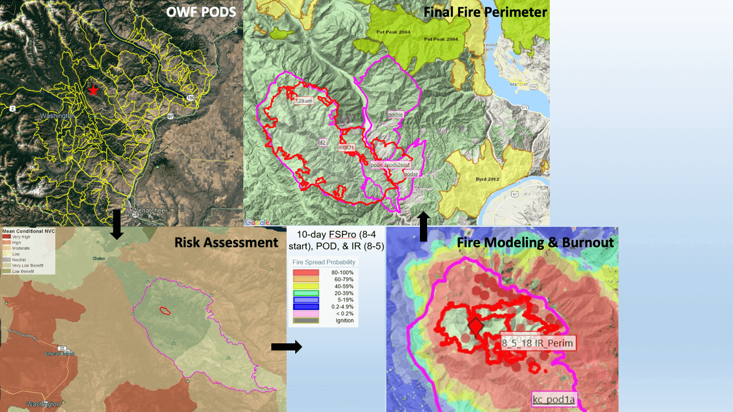
POD and risk assessment information was made available to the IMT and referenced by the line officer and local staff while communicating strategy and containment. The IMT validated the POD boundaries, prepped several of them, and began to carry fire from the north to the south on the eastern boundary. Values inside the POD were protected. A week later, when the POD boundary was breached to the SE, the next PODs were utilized to aid in the containment of the fire. Ultimately, the fire was contained at about 42,000 acres; firefighters, the public, and other assets and resources were protected, the fire-adapted ecosystem benefited with a burn severity largely low to moderate, and the future threat to HVRAs from large fires has been reduced for several years.
How to begin the SWFMP process
Meet as a unit fire organization and discuss the need (the “why”) and if the process will work given your landscape, resources, current leadership, and partners. Identify the personnel and skills required. What partners are important to the process? Share your ideas with other fire managers. Take the proposal to your line officer who can help champion the effort and facilitate a discussion with adjoining units on contributing to and supporting the process. Receive a formal by-in—which includes if you are going to build it, line, IMTs, and your local fire organization are going to use it. Identify PCLs with maps and highlighters or turn to the Forest Service, Rocky Mountain Research Station to develop the PCLs. The more agencies and cooperators you invite to the process—in a workshop setting—the more apt they will be to support and embrace the strategy when there is a wildfire. Group the PCLs into PODs. Make these PODs available in GIS for local and IMT use on fires and in WFDSS. Monitor the product and the process and revise as conditions and personnel change. Remember to start small and keep it simple. We can’t expect to undo forest practices of a century in a year or even a decade—incremental progress is the goal, starting with areas with a higher degree of success and leveraging past fires. If you can’t implement the entire SWFMP framework, then do what you can, even if it is just the use of PCLs.
In the off season, make the PCLs and/or PODs available in WFDSS, and in Google Earth, GIS, and map form for local use and incoming teams. Pre- and post-season fuel treatment work should utilize the PODs and be part of a landscape strategy for restoration and protection of HVRAs. Line officers should refer to the PCL, POD, and QWRA data in their leader’s intent letter/delegation of authority to local and incoming IMTs and should be echoed in the WFDSS decision (incident objectives, course of action, and rationale).
Time for a deliberate change in strategy
The Cohesive Wildland Fire Management Strategy identified three primary factors as the greatest challenges and opportunities we face in wildland fire management: (1) restoring and maintaining resilient landscapes, (2) creating fire-adapted communities, and (3) responding to wildfires. Implementing SWFMP on fire-prone landscapes will help us achieve the goals and performance measures pertinent to these three focus areas. When one considers the toll that recent wildfires have had on lives, communities, and the environment, we really have few alternatives. We can continue to battle—often unsuccessfully—or where we have decision space, we can think, talk, plan (especially preplan) and act more strategically. The science has been suggesting this approach for years, and fire’s response on the landscape is now forcing us to think differently about our wildland fire management practices. Isn’t it about time we change?
+
Acknowledgements
The author appreciates helpful reviews from Kit O’Connor, Chris Dunn, Morgan Pence, and Joe Scott, and statistical support from Teresa Alcock, Molly Cox, Barb Haney, Brian Maier, and Sunny Ng.
Bio
Rick Stratton ([email protected]) is a fire analyst at the US Forest Service, National Office, Fire and Aviation Management. His wildland fire interests include geospatial fire modeling, long-duration fire support, fuel treatment design and effectiveness, risk assessment, and wildland-urban interface home ignitability assessments and destruction investigations.
References
Bahro, Bernhard; Barber, Klaus H.; Sherlock, Joseph W.; Yasuda, Donald A. 2007. Stewardship and fireshed assessment: a process for designing a landscape fuel treatment strategy. Restoring fire-adapted ecosystems: proceedings of the 2005 national silviculture workshop, Gen. Tech. Rep PSW-GTR-203, p. 41-54.
Booz Allen Hamilton. 2015. 2014 Quadrennial Fire Review final report. Washington, DC: USDA Forest Service, Fire and Aviation Management; USDI Office of Wildland Fire. 79 p.
Finco, Mark; Quayle, Brad; Zhang, Yuan; Lecker, Jennifer; Megown, Kevin A.; Brewer, C. Kenneth. 2012. Monitoring Trends and Burn Severity (MTBS): Monitoring wildfire activity for the past quarter century using landsat data. In: Morin, Randall S.; Liknes, Greg C., comps. Moving from status to trends: Forest Inventory and Analysis (FIA) symposium 2012; 2012 December 4-6; Baltimore, MD. Gen. Tech. Rep. NRS-P-105. Newtown Square, PA: U.S. Department of Agriculture, Forest Service, Northern Research Station. [CD-ROM]: 222-228.
Finney, M., I.C. Grenfell, and C.W. McHugh. 2009. Modeling containment of large wildfires using generalized linear mixed-model analysis. For. Sci. 55(3):249-255.
Finney MA, McHugh CW, Grenfell IC (2005) Stand- and landscape-level effects of prescribed burning on two Arizona wildfires. Canadian Journal of Forest Research 35, 1714–1722.
Gilbertson-Day, Julie W.; Stratton, Richard D.; Scott, Joe H.; Vogler C., Kevin; Brough, April. 2018. Pacific Northwest Quantitative Wildfire Risk Assessment: Methods and Results. Final report.
Hessburg P.F. 2017. Why wildfires have gotten worse—and what we can do about it. Tedx Bend, OR, presented May 2017. URL: https://www.ted.com/talks/paul_hessburg_why_wildfires_have_gotten_worse_and_what_we_can_do_about_it.
McHugh, C.W. and Finney, M.A. 2014. Estimating Historical Annual Wildland Fire Burning Rates for the Contiguous United States. Presented: The large wildland fires conference; May 19-23, 2014; Missoula, MT. Presentation was recorded and is available for viewing here: https://mediasite.for.uidaho.edu/Mediasite/Play/a30a5e19a9ac43a1b559e9c808a125cd1d.
Noonan-Wright, Erin; Opperman, Tonja S.; Finney, Mark A.; Zimmerman, G. Thomas; Seli, Robert C.; Elenz, Lisa M.; Calkin, David E.; Fiedler, John R. 2011. Developing the U.S. Wildland Fire Decision Support System. Journal of Combustion. 2011: Article ID 168473. 14 p.
O’Connor, Christopher D.; Calkin, David E. 2019. Engaging the fire before it starts: A case study from the 2017 Pinal Fire (Arizona). Wildfire. 28(1): 14-18.
O’Connor, Christopher D.; Calkin, David E.; Thompson, Matthew P. 2017. An empirical machine learning method for predicting potential fire control locations for pre-fire planning and operational fire management. International Journal of Wildland Fire. 26: 587-597.
Promoting Active Management of America’s Forests, Range-lands, and Other Federal Lands to Improve Conditions and Reduce Wildfire Risk. Federal Register, Vol. 84, No. 4, Monday, January 7, 2019. Presidential Documents Executive Order 13855 of December 21, 2018.
Radeloff, V.C.; Helmers, D.P.; Kramer, H.A.; Mockrin, M.H.; Alexandre, P.M.; Bar-Massada, A.; Butsic, V.; Hawbaker, T.J.; Martinuzzi, S.; Syphard, A.D.; et al. 2018. Rapid growth of the US wildland-urban interface raises wildfire risk. Proc. Natl. Acad. Sci. USA.
Reason, J. 1990. “The Contribution of Latent Human Failures to the Breakdown of Complex Systems”. Philosophical Transactions of the Royal Society of London. Series B, Biological Sciences. 327 (1241): 475–484. doi:10.1098/rstb.1990.0090.
Reason, James (2000-03-18). “Human error: models and management”, British Medical Journal. 320 (7237): 768–770.
Reducing Wildfire Risks on Department of the Interior Land through Active Management. 2019. Order No. 3372. USDI, Jan. 2.
Rollins, Matthew G.; Frame, Christine K., tech. eds. 2006. The LANDFIRE Prototype Project: nationally consistent and locally relevant geospatial data for wildland fire management. Gen. Tech. Rep. RMRS-GTR-175. Fort Collins: U.S. Department of Agriculture, Forest Service, Rocky Mountain Research Station. 416 p.
Scott, Joe H.; Thompson, Matthew P. 2015. Emerging concepts in wildfire risk assessment and management (Publ.). In: Keane, Robert E.; Jolly, Matt; Parsons, Russell; Riley, Karin. Proceedings of the large wildland fires conference; May 19-23, 2014; Missoula, MT. Proc. RMRS-P-73. Fort Collins, CO: U.S. Department of Agriculture, Forest Service, Rocky Mountain Research Station. p. 196-206.
Scott, Joe H.; Thompson, Matthew P.; Calkin, David E. 2013. A wildfire risk assessment framework for land and resource management. Gen. Tech. Rep. RMRS-GTR-315. U.S. Department of Agriculture, Forest Service, Rocky Mountain Research Station. 83 p.
Stratton, Richard D. 2019. Webinar Presentation: Overview and Applications of the PNW Quantitative Wildfire Risk Assessment. Northwest Fire Science Consortium. April 24.
Stratton, Richard D. 2006. Guidance on spatial wildland fire analysis: models, tools, and techniques. Gen. Tech. Rep. RMRS-GTR-183. Fort Collins, CO: U.S. Department of Agriculture, Forest Service, Rocky Mountain Research Station. 15 p.
Thompson MP, Bowden P, Brough A, Scott JH, Gilbertson-Day J, Taylor A, Anderson J, Haas JR. 2016. Application of wildfire risk assessment results to wildfire response planning in the southern Sierra Nevada, California, USA. Forests 7, 64.
Toward Shared Stewardship Across Landscapes: An Outcome-Based Investment Strategy. 2018. FS-1118. USDA FS.
U.S. Department of Agriculture, Forest Service. 2018. A Statement from Forest Service Chief on executive order promoting active management. News Release. Dec. 21.
U.S. Department of Agriculture, Forest Service; Department of the Interior, Office of Wildland Fire Coordination. 2011. A national cohesive wildland fire management strategy. Washington, DC: Wildland Fire Leadership Council. 43 p.
U.S. Department of Agriculture, Forest Service; Pacific Northwest Regional Office. 2015. Narrative timeline of the Pacific Northwest 2015 fire season. Portland, OR. 281 p.